THE FORBIDDEN ISLE
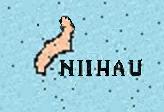
Ni'ihau lies 17 mile off the west coast of Kauai, and is inhabited by about 200 full-blooded Hawaiians. Ni'ihau's companion, Lehua lies off it's northeastern end. |
|
Size: 18 miles by 6 miles Land Area: 47,217 acres; 46,705 acres owned privately, 256 acres ,owned by State; 256 acres Federal Shoreline: 45 miles long, tidal shoreline is 50 miles and 3 miles are cliffs
Mean Altitude: 530 ft Highest Point: Paniau: 1,281 ft Lehua Islet : 702 ft
Lakes: Halali'i, 841 acres and Halulu, 182 acres which is brackish, and mullet is raised in it. At times of severe drought it dries up. At times when the water evaporates, they trench around it and the water and fish survive in the deeper trench until the rains come. This is being used today. [Gabriel I: Personal Comm. May 1971]
Economic Activities have included ranching, fishing, charcoal production, honey cultivation, and big game hunting..
Census 1980: 226 Town: Pu'uwai [originally was Kauanaulu] and Pu'uwaiAloha’oka’Ohana.
Plant: Pupu-o-Ni’ihau (Ronck’s Hawaiian Annual [ 19__])
|